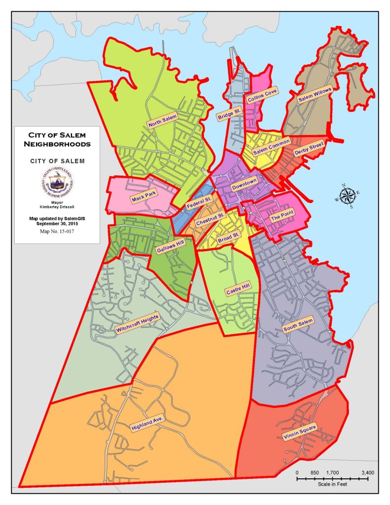
SALEM’S HISTORIC NEIGHBORHOODS
Salem’s neighborhoods reflect centuries of change along a coastline shaped by both nature and human activity. Long before European colonists arrived in the early 17th century, Indigenous peoples lived, traveled, and fished along these shores, calling the area Naumkeag, an Algonquin word often translated as “Fishing Place.” Over time the peninsula that forms present-day Salem expanded through filled land, reshaping the harbor’s edge and creating new streets, wharves, and communities.
By the late 18th and early 19th centuries Salem had become one of the most prosperous ports in the young United States, leaving behind an extraordinary architectural legacy—from the elegant Federal designs of master builder Samuel McIntire to the maritime landmarks of Derby Street. The city’s history also includes the tragedy of the 1692 witch trials, the literary legacy of Nathaniel Hawthorne, and the Great Salem Fire of 1914 which resulted in the rebuilding of Salem. Today, Salem’s neighborhoods reveal these many layers of history—each one offering a different window into the city’s past.
DOWNTOWN
Downtown Salem forms the historic heart of the city, where four centuries of civic, commercial, and cultural life have unfolded.
Centered around Essex Street, Washington Street, and Derby Square, the district developed from Salem’s early colonial settlement into a thriving commercial center during the city’s maritime trading era of the late 18th and early 19th centuries.
Today the neighborhood contains an impressive collection of brick and granite commercial buildings spanning more than two centuries, reflecting Salem’s evolution from a global port to a bustling 19th-century mercantile city and modern cultural destination. Interspersed among the commercial blocks are many of Salem’s most significant civic landmarks.
During the mid-20th century, downtown Salem experienced a period of urban renewal that reshaped parts of the historic district. Several significant buildings were lost during this era, including the Boston and Maine Railroad Depot (1847), a grand granite train station that once stood near Washington Street before its demolition in 1954 as part of plans to route a highway through the city center. In the decades that followed, preservation efforts and thoughtful redevelopment helped protect many of downtown’s remaining historic structures, and today the area is recognized as the Downtown Salem National Register Historic District.
Historic Highlights:
- John Ward House (1684)
- Samuel Pickman House (before 1681)
- Old Town Hall (1816)
- Gardner-Pingree House (1806)
- Andrew-Safford House (1818)
- Essex County Court Buildings
- Salem City Hall (1837)
- Salem Jail complex (1813)
- East Church (1846)
- East India Marine Hall, Peabody Essex Museum (1825)
- Plummer Hall (1856)
- U.S. Post Office (1933)
- Daniel Low Building (1826)
- Joshua Ward House (c. 1788)
- YMCA Building (1898)
- Kinsman Block (1882)
- Masonic Temple (1916)
- Tabernacle Church (1924)
- Charter Street Burial Ground (1637)
- Howard Street Cemetery (1801)
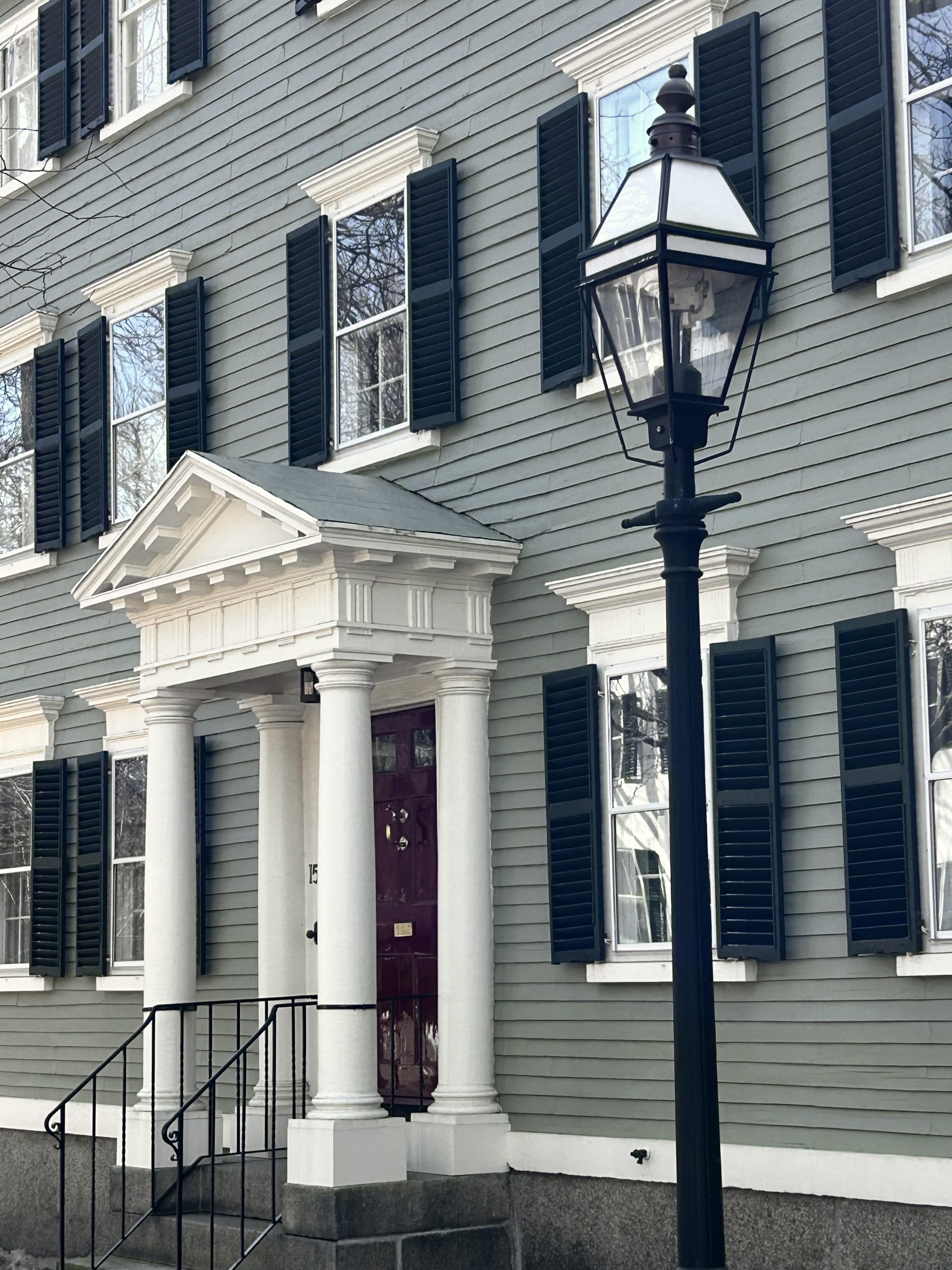
MCINTIRE DISTRICT & BROAD STREET
Bordering downtown Salem to the west, the McIntire District (including the Federal St and Chestnut St neighborhoods) and Broad Street neighborhood contain some of the city’s most celebrated historic architecture.
The area is widely recognized for its remarkable collection of Federal-period homes built during Salem’s late 18th and early 19th century maritime prosperity, when the city was one of the wealthiest ports in the young United States.
Elegant mansions line Chestnut Street, often considered one of the finest Federal streetscapes in America, while Federal Street features an impressive sequence of Federal and Greek Revival residences. Surrounding streets include additional architectural layers, from early 19th-century merchant houses to Victorian-era and Classical Revival homes around Broad Street.
Much of the district’s architectural character is associated with Samuel McIntire (1757–1811), Salem’s renowned master builder, architect, and woodcarver whose refined Federal-style designs helped define the city’s architectural identity. Many homes in the district were built for Salem’s merchant elite during the height of the city’s global maritime trade.
Today the neighborhood remains one of the most intact historic residential districts in the United States and is protected through both National Register listing and designation as a Local Historic District.
Historic Highlights:
- Jonathan Corwin House, The Witch House (1675)
- Pickering House (c. 1651)
- Hamilton Hall (1807)
- Pierce-Nichols House (c. 1782)
- Nathaniel Bowditch House (c. 1805)
- Cotting-Smith Assembly House (1782)
- Gedney House (c. 1665)
- Phillips House (early 19th c.)
- William Brown Cottage (1847)
- Salem Athenaeum (1907)
- Salem Public Library (1855)
- Putnam-Balch House, “Greymoor” (1872)
- First Church in Salem (1836)
- Ropes Mansion and Gardens (late 1720s)
- State Normal School (1853)
- Broad Street Cemetery (1655)
- Friends Quaker Burying Ground (1688)
- Orne Square (post 1914)
- Ward 3 Fire Station (1915)
DERBY STREET
Stretching along Salem Harbor, Derby Street is one of the city’s oldest and most historically significant neighborhoods.
Its narrow streets and waterfront setting reflect Salem’s deep maritime heritage, with buildings and landscapes that span more than four centuries of development.
The area grew rapidly during the late 18th century when Salem became one of the young nation’s most important seaports. Much of this activity was driven by Elias Haskett Derby (1739–1799), a prominent Salem merchant whose global trading ventures helped establish the city as a center of international commerce. The wharves, warehouses, and merchant houses that developed along the harbor during this period helped define the neighborhood’s character and its enduring connection to the sea.
Today Derby Street contains a remarkable mix of 17th-, 18th-, and 19th-century homes, historic wharves, and maritime landmarks. The neighborhood is anchored by the Salem Maritime National Historic Site—the first National Historic Site established by the National Park Service—and The House of the Seven Gables, one of Salem’s most visited historic properties. The area also has strong literary ties to Nathaniel Hawthorne, who worked at the nearby Salem Custom House and drew inspiration from Salem’s waterfront history in several of his writings.
Historic Highlights:
- Salem Maritime National Historic Site
- The House of the Seven Gables, Turner House (1668)
- Nathaniel Hawthorne Birthplace (between 1730-1745)
- Salem Custom House (1819)
- Derby Wharf (1762)
- Derby Wharf Lighthouse (1871)
- Narbonne House (c. 1672)
- Hooper-Hathaway House (c. 1682)
- Retire Beckett House (c. 1687)
- Derby House (1762)
SALEM COMMON
The Salem Common neighborhood centers on one of the city’s most iconic historic landscapes.
Established in the early 17th century as a public grazing ground, the Common also once stood at the edge of a working waterfront community where ropewalks and other maritime industries operated nearby. Modest houses for tradespeople and laborers once surrounded the open field—few of which survive today—but during the late 18th and early 19th centuries the area gradually transformed as Salem’s maritime prosperity attracted merchants, sea captains, and civic leaders who built more substantial homes overlooking the park.
Surrounding the Common and extending along its radiating streets is an impressive collection of Georgian, Federal, Greek Revival, and Victorian-era homes. Built for merchants, sea captains, and civic leaders during Salem’s maritime prosperity and later periods of growth, this neighborhood represents some of the city’s most visually striking historic streetscapes.
Together, the park and its surrounding architecture create one of Salem’s most cohesive and recognizable historic districts, protected today through both Local Historic District designation and National Register listing.
Historic Highlights:
- Salem Common (c. 1660s, established as formal park 1802)
- Roger Conant statue (1913)
- Daniels House (1667)
- Salem Common Bandstand (c. 1926)
- Hawthorne Hotel (1925)
- St. Nicholas Russian Orthodox Church (1908)
- Clifford Crowninshield House (1806)
- Bertram House (1855)
- Daniel Bray House (1766)
- Charles E. Fairfield House (1892)
- Baldwin-Lyman House (1812)
- Payson-Fettyplace House (c. 1845)
THE POINT
Located between Salem’s South River and Palmer Cove just south of downtown, The Point is one of the city’s most distinctive historic neighborhoods.
Early colonists called the area “Stage Point,” referring to the wooden fishing stages where fish were unloaded, cleaned, and dried along the waterfront. During the 19th century the neighborhood grew rapidly with the arrival of the Naumkeag Steam Cotton Company, whose mills and nearby housing supported a large immigrant workforce. Over time the area became known as “La Pointe,” reflecting the strong French Canadian community that settled here.
The neighborhood’s present architectural character was largely shaped by the Great Salem Fire of 1914, which destroyed most of the district. In the years that followed, The Point was rebuilt quickly, with many new buildings constructed within just a few years. Fire safety concerns and new building standards encouraged the use of brick and masonry construction, resulting in a dense and cohesive neighborhood of early 20th-century apartment buildings, row houses, and multi-family homes originally built to house workers connected to the Naumkeag mills and other local industries.
Today The Point, or “El Punto”, remains one of Salem’s most vibrant and culturally rich neighborhoods. In recent years the area has become home to the Punto Urban Art Museum, a mission-driven open-air art museum featuring more than 75 large-scale murals created by local and internationally recognized artists on the neighborhood’s historic brick facades.
Historic Highlights:
- Point Neighborhood Historic District (2014)
- Pequot Mills, Naumkeag Steam Cotton Company Complex, Shetland Park (1914)
- Masonry Row Houses (1917)
- Punto Urban Art Museum (2017)
- Palmer Cove waterfront
BRIDGE STREET NECK & COLLINS COVE
Located on a narrow peninsula between Salem’s downtown, the Danvers River, and Beverly Harbor, Bridge Street Neck and Collins Cove is one of the city’s earliest settled areas.
Bridge Street itself—originally known as Ferry Lane and established in the mid-18th century—served as an important route connecting Salem to communities north of the harbor.
Today the neighborhood is a densely developed residential area characterized by a rich collection of Federal, Greek Revival, and Victorian-era homes, many built during Salem’s 19th-century growth as maritime trade and industry expanded along the waterfront. The commercial corridor along Bridge Street developed alongside these residential streets, creating a lively mix of historic storefronts, converted houses, and neighborhood businesses.
The area’s architectural significance was formally recognized in 2002 with the listing of the Bridge Street Neck Historic District on the National Register of Historic Places. Nearby Collins Cove provides waterfront access and sweeping harbor views that have long shaped the neighborhood’s character.
Historic Highlights:
- Bridge Street Historic District
- Thomas March Woodbridge House (1805)
- Thaddeus Gwinn House (c. 1805)
- Arabella Street Cottages (late 19th century)
- Historic Bridge Street commercial blocks (c. 19th century)
EXPLORE SALEM’S HOUSE HISTORIES
Every house has a story. HSI’s House History & Plaque Program has researched and documented hundreds of Salem homes—from early colonial dwellings to Victorian landmarks—connecting today’s neighborhoods with the people and events that shaped them.
Explore the growing database of Salem house histories and discover the stories behind the buildings around you.
NORTH SALEM & MACK PARK
The North Salem and Mack Park neighborhoods lie north of Salem’s historic downtown and contain a diverse collection of 18th-, 19th-, and early 20th-century homes that reflect the city’s gradual expansion beyond its colonial core.
Much of the area was once part of the North Fields, open farmland associated with early Salem families such as the Cabots, before residential development transformed the landscape in the 19th century.
The neighborhood includes a mix of architectural scales and housing types. Larger single-family homes developed in the Northfields area, while more modest worker housing appeared closer to the North River and former industrial areas near Mack Park. This variety of housing illustrates the changing social and economic character of Salem as the city grew during the industrial era.
Running between these areas is North Street, a historic corridor lined with converted residences, small commercial buildings, and civic structures that have long served the surrounding community. North Salem is also notable for its significant historic landscapes, including several large cemeteries and open green spaces that help define the character of the neighborhood.
Historic Highlights:
- Dickson Memorial Chapel, Greenlawn Cemetery (1894)
- Blake Memorial Chapel, Harmony Grove Cemetery (1905)
- North Street Fire Station (1882)
- Carolton-Waters Cottage (c. 1852)
- Job V. Hanson House (1874)
- Greenlawn Cemetery (1801)
- Harmony Grove Cemetery (1840)
- Dr. William Mack House, Mack Park (c. 1874)
- Efraim Woods House (1855)
- North Branch Library (1934)
SOUTH SALEM & VINNIN SQUARE
Located between The Point neighborhood and the Swampscott town line, South Salem and Vinnin Square reflect Salem’s expansion beyond its historic downtown during the late 19th and early 20th centuries.
Tree-lined residential streets in South Salem contain one of the city’s most impressive collections of Victorian-era and early 20th-century homes, including richly detailed examples of Queen Anne and Shingle Style architecture, as well as more restrained Colonial Revival residences built during the early 1900s. Parts of the neighborhood were rebuilt after the Great Salem Fire of 1914, which destroyed large sections of the Lafayette Street corridor and shaped the area’s early-20th-century architectural character.
The area is also shaped by several important civic and landscape features. Salem State University’s campus, with its distinctive yellow brick buildings, occupies a prominent place in the neighborhood, while nearby Forest River Park and Pioneer Village provide historic open spaces along Salem’s waterfront.
Further south, the residential area of Vinnin Square developed largely during the 20th century and includes a mix of Craftsman bungalows, Colonial Revival homes, and mid-century Ranch and Cape-style houses. Together, these neighborhoods reflect the changing architectural tastes and residential growth of Salem during the late 19th and 20th centuries.
Historic Highlights:
- Loring Villa (1870)
- Pioneer Village, replica (1930)
- Forest River Park (1907)
- William H. Gove House (1888)
- Henry M. Brooks House (1851)
- Edward P. Balcomb Cottage (1870)
- Benjamin G. Hathaway House (1874)
- Sullivan Building, Salem State University (1897)
- Horace Mann Building, Salem State University (1912)
- Salem Diner (1941)
SALEM WILLOWS & WINTER ISLAND
Salem Willows and Winter Island reflect Salem’s long relationship with the sea and the city’s tradition of waterfront recreation.
Located along Salem Harbor and the open waters of Massachusetts Bay, these areas developed during the 19th century as popular destinations for seaside leisure, offering ocean breezes, scenic views, and access to the shoreline.
At the heart of the neighborhood is Salem Willows Park, one of the oldest seaside amusement parks in the United States. Established in the mid-19th century, the park became a beloved gathering place for residents and visitors alike, with promenades, arcades, and waterfront attractions set among the distinctive willow trees that gave the area its name. Nearby, Juniper Point developed as a small summer cottage community where Victorian-era houses took advantage of sweeping views of Salem Harbor, while the historic Camp Naumkeag complex and Plummer Hall reflect the area’s long tradition of seaside recreation and youth programming.
Just offshore, Winter Island contains a rich collection of historic military and maritime resources. The island has served as a strategic coastal defense site since the 17th century and today includes the remains of Fort Pickering and the Winter Island Lighthouse, both overlooking Salem Harbor.
Historic Highlights:
- Juniper Point Cottages (1870s)
- Winter Island Lighthouse (1871)
- Plummer Home (1857)
- Baker’s Island Lighthouse (c. 1820)
- Camp Naumkeag (1910)
- Fort Pickering (1643)
- Fort Lee (1776)
- Sea Plane Hanger (1934)
CASTLE HILL
Located west of the railroad tracks and south of the Broad Street neighborhood, Castle Hill was once open pastureland known as the Great Pasture and formed part of the Derby family estate.
In the 1830s, the Derby family sold portions of the land to the Boston & Maine Railroad, which blasted the top of the hill to construct rail lines connecting Salem to Boston and northern New England.
Beginning in the 1850s, residents—many of them French Canadian families relocating from the densely populated Point neighborhood—settled in Castle Hill, drawn by its more open setting. Development accelerated in the early 20th century after a new bridge improved connections between the neighborhood and downtown Salem.
Castle Hill today reflects this period of working-class residential growth. Its streets are lined with modest late-19th and early-20th century homes, including Victorian cottages, Queen Anne and Colonial Revival houses, and Craftsman-style bungalows. Many streets feature repeating house forms and porch-lined facades, creating a distinctive and cohesive neighborhood character.
Historic Highlights:
- Boston & Maine Railroad corridor
- Sainte Anne’s Church (1902)
- Old Salem High School, serves today as Collins Middle School (1909)
- Salem Hospital, original building (1917)
GALLOWS HILL & WITCHCRAFT HEIGHTS
The Gallows Hill and Witchcraft Heights area includes several distinct neighborhoods that together reflect multiple chapters of Salem’s history.
Gallows Hill has long been associated with the events of the 1692 Salem witch trials. While the hill itself became linked with the tragedy over time, historians now believe the executions took place at Proctor’s Ledge, a rocky outcrop at the base of the hill.
During the 19th century, Boston Street developed as an important residential and commercial corridor connecting Salem to surrounding communities. Nearby, the low-lying area known as Blubber Hollow grew into an industrial district along the North River Canal, home to factories, workshops, and modest worker housing. The neighborhood’s colorful name likely references Salem’s maritime past, when whale blubber was processed into oil for lighting and trade.
Further west, Witchcraft Heights developed primarily during the mid-20th century as Salem expanded beyond its historic core. Ranch and split-level homes built during the postwar years reflect the city’s transition into a modern residential community.
Historic Highlights:
- Pope House (c. 1717)
- Joseph Hodges Choate statue (1923)
- Dairy Witch (1952)
- Arthur J. Mulholland Company (c. 1900)
- Epes Grammar School (c. 1840)
HIGHLAND AVENUE
The Highland Avenue area forms one of Salem’s primary western gateways, extending from the downtown toward the city’s borders with Lynn and Peabody.
The neighborhood developed along Highland Avenue, originally established in the early 19th century as the Salem & Boston Turnpike, an important regional route connecting Salem with communities to the south.
Unlike Salem’s older waterfront and downtown neighborhoods, much of the Highland Avenue area reflects the city’s 20th-century expansion. Residential streets include examples of mid-century housing styles, while commercial plazas and businesses developed along the Highland Avenue corridor as automobile travel reshaped the area after World War II.
The neighborhood also contains several civic and landscape features that serve the broader Salem community. The Salem Woods provides wooded trails and open space within the city, and sits adjacent to Salem’s high school. Fewer historic resources have been formally documented here than in Salem’s older neighborhoods.
Historic Highlights:
- Salem Woods (1906)
- Old Salem Green Public Golf Course (1933)